|
Abandoned Rails
<
Main Page
Virginian Railway -
First Subdivision (Norfolk Division)
Sewell's Point to
Victoria
|
The Virginian Railway is
well-known as one of the three major Appalachian coal hauling railroads,
along with the Norfolk & Western (N&W) and the Chesapeake & Ohio.
As a result of the
December 1, 1959
takeover by the N&W, much of the trackage that comprised the First
Subdivision became redundant in relation to the N&W's Norfolk to Roanoke mainline, with little business along the way.
Over time the line
between Algren and Abilene was abandoned although some of the rail
remained intact until the early
1990's.
Since 2001 I have documented various segments
of the remaining trackage and right-of-way that once comprised the
First Subdivision. In fact, this page was the catalyst for the Abandoned Rails section of the website.
I would like to thank Steve Hammer, Chuck Rippel, Bill Whitbeck, and Sam Holden
for their contributions to this page. If you have information or
photographs that you'd like to share,
please
e-mail me. |

|
Sewell's Point (A8.0)
Sewell's Point was the
eastern terminus of the Virginian Railway and named after Henry Sewell.
There were two coal piers used to load the colliers. On the left
is Coal Pier No. 1 that was built in 1909 and completed for a cost of
$2.5 million. On the right is Coal Pier No. 2, completed in 1925
and later upgraded in late 1950's. Both served the VGN faithfully
until it's 1959 merger with the N&W at which time coal loading
operations were transferred to the N&W's Lambert's Point facility.
The piers physically survived until 1966 when they were sold to the U.S.
Navy. The demise of Sewell's Point resulted from it becoming a
redundant facility, especially after coal loading
operations were transferred to nearby Lambert's
Point. The yard was used for the storage of
coal cars into the early 1970's and was finally
abandoned when the U.S. Navy wanted to expand
the main runway on the base. Today various
aspects of Naval Station Norfolk occupies all of the land
that was once comprised of the coal piers, ground storage facility, engine terminal
and yard at Sewell's Point. There is no remaining evidence of any
of these facilities today.
Photo by Evan Siler
(June 1961) |

|
Quartermaster Junction (A5.8)
This view is looking railroad east from Granby
Street in Norfolk towards Sewell's Point. Underneath the I-564 bridge
in the distance is
Quartermaster Junction. Here the track branches off and continues
compass west one mile to Norfolk International Terminals. Continuing
past Quartermaster Junction will take you on to West Junction
(where the former Virginian mainline now terminates)
and onto the property
of Naval Station Norfolk where the Sewell's Point facility was once
located. The line was double-tracked until
around 1990 when the former eastbound main was
removed east of Thole Street.
Photo by Jeff Hawkins
(March 15, 2003) |

|
Coleman Place (A1.4)
Situated northeast of downtown
Norfolk near the intersection of Ballentine
Boulevard and East Princess Anne Road was Coleman
Place. It was
at Coleman Place where the Norfolk Southern Railway
(Southern Railway after 1974)
crossed the Virginian at grade. This was
Norfolk Southern's North Beach Route between Little
Creek and their connection with the N&W mainline at
Goff Street.
The tower here was one of several
located along the Virginian throughout the Tidewater
area. As you will see in the proceeding
photos, it is of the typical architecture and
material for
towers the company built in the 1940's. The
building seen in the photo was erected in 1946. While the structure was built by the Virginian, it
was staffed by Norfolk Southern dispatchers.
In 1929 the Pennsylvania Railroad
relocated it's car float operation from downtown
Norfolk to Little Creek, and constructed a freight
station at Goff Street and Hanson Avenue. To
accommodate their new operation, the Pennsylvania
acquired trackage rights over the Norfolk Southern
line between Little Creek and Goff Street where both
railroads interchanged with the N&W via a connection
track. Coincidentally the former connection
track is now part of the wye utilized for the new
Amtrak service to Norfolk which commenced in
December 2012. Other developments in 1929
included the installation of connection tracks at
Coleman Place along with the addition of a second
mainline track between Coleman Place and Camden
Heights. Adding to the mix was the Norfolk &
Portsmouth Beltline Railroad which also had trackage
rights over the line from Coleman Place to Little
Creek where they interchanged with the Pennsylvania. As
business declined in the subsequent decades, the
second track was taken up and the line between
Coleman Place and Goff Street was abandoned.
The diamond at Coleman Place was removed in 2006.
Out of the four towers along the
Virginian mainline in the Tidewater area, Coleman
Place remained in operation the longest.
During it's latter years of use, the operator at
Coleman Place was charge with overseeing all
movements on the Sewell's Point Branch (Sewell's
Point to Tidewater Tower). Eventually this
responsibility was transferred to the operator at
Bridge 5, which carried the N&W mainline across the
Eastern Branch of the Elizabeth River on the edge of
downtown Norfolk.
Today the Bay Coast
Railroad (formerly Eastern Shore Railroad) operates the
car float between Little Creek and Cape Charles, and
operates over trackage between Little Creek and
Coleman Place. The Bay Coast operates over the
former Virginian mainline between Coleman Place and
South Norfolk in order to interchange with Norfolk
Southern at Portlock Yard.
Photo by Jeff Hawkins
(August 2, 2003) |

|
Carolina Junction (V4.5)
The Norfolk Southern Railway's
mainline from Elizabeth City, NC crossed the Virginian
at grade at Carolina Junction in the City of Chesapeake. The diamond was located
approximately 200' to the
left of the tower. Just south of Carolina Junction was Norfolk
Southern's Carolina Yard, which was the railroad's
primary yard and servicing facility in Tidewater area. In the
foreground is the former Virginian mainline with the northeast connection track visible in
the background. This connection led to the former Norfolk Southern
line
between Carolina and NS Junction. This track
is now unused since the diamond at NS Junction was
removed in recent years. Following the
formation of the Norfolk Southern Corporation in 1982,
the track configuration at Carolina underwent a
number of changes. The diamond and the
connection track in the southeast quadrant were
removed. A new connection track was then built
in the southwestern quadrant of Carolina to allow
trains access to nearby Portlock Yard. Today
the former NS line south of Carolina is utilized by
the Chesapeake & Albemarle Railroad, a shortline
based out of Ahoskie, NC.
Photo by Jeff Hawkins
(August 2, 2002) |

|
South Norfolk (V5.1)
There were only two locations where
the Virginian Railway intersected with the N&W's
mainline between Tidewater and the coal fields of
West Virginia. At Glen Lyn, VA the Virginian
soared over the N&W on a massive bridge which also
carried the railroad across the New River. The
other location was in the City of South Norfolk,
which merged with Norfolk County in 1963 to form the
independent city of Chesapeake. Of the
countless diamonds in the
Tidewater area, South Norfolk was the busiest. In addition to the
endless parade of coal trains, manifest and
passenger trains of both railroads pounded the
diamond at South Norfolk day and night for decades.
In the photo above, the Virginian mainline ran
through the grassy area and between the two
poles in the right side of the photo. The track in the foreground
leads to Portlock Yard (ex-N&W) and is the
former connection track between the Virginian and
N&W.
This connection and the one in the northwest quadrant dates back to the Virginian era
and allowed traffic to be interchanged by the two
railroads.
The diamond was removed in August 1969 at which time
an
additional connection track was installed in the northeast
quadrant of the interlocking. The structure seen in the distance
was the Virginian's interlocking tower at South Norfolk.
Photo by Jeff Hawkins
(August 2, 2003) |


|
South Norfolk Tower (V5.1)
This building was the Virginian
Railway's interlocking tower at South Norfolk where the
Virginian and N&W mainlines crossed at grade. The stucco building was
constructed in 1946 and replaced a wooden two-story tower that
stood in the northwest quadrant of the diamond were
the Virginian crossed the N&W mainline at grade. The
diamond was removed in August 1969 and the tower was
demolished in November 2012.
Top photo by Jeff Hawkins
(January 16, 2011)
Bottom photo by Jeff Hawkins
(August 2, 2003) |

|
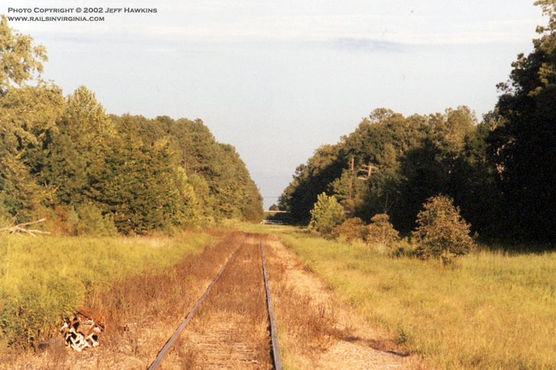
Chesapeake
Here we are looking west towards Suffolk from the
City of Chesapeake. This photo was taken at the Ramp Shop Road grade
crossing which is approximately one mile west of the South Branch Bridge
over the Elizabeth River. There is a cement plant just behind me and I
believe it's the westernmost business on the existing Jarratt
District trackage in Tidewater. I have not investigated the line any further to the west
through Chesapeake, but plan to do so in the future.
Photo by Jeff Hawkins - August 2, 2003
|

|
Sunray - Homestead Road
This view is looking south
on Homestead Road near Sunray toward it's intersection with Sondej Road.
The former VGN mainline is still easily identifiable.
Photo by Sam Holben - March 2010
|

|
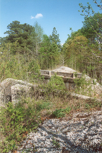
Algren
This small concrete bridge
is located about 2/3 of a mile west of the former crossing at Algren
along Sondej Avenue. If you look closely you'll see exposed rail
above the center of the structure.
Photo by Sam Holben - March 2010
|

|
Algren - V15.4
About halfway between Norfolk and Suffolk, the Virginian
crossed the Seaboard Air Line (SAL) at grade. This location was known as
Algren and is easily accessible from US 460. This photo is just east
of Algren looking south down Snowden Road where it intersects with Sondej Avenue. This old grade crossing is about 1,000 ft. east of where
the diamond was once located. One can only guess at what purpose the
concrete base to the left of the road served. It's on the wrong side of
the road for a crossing gate. Perhaps it served as the base for
the distant signal to the diamond?
Photo by Jeff Hawkins - August 2, 2003
|

|
Algren - V15.4
This photo is looking east
along the former SAL mainline at Algren. Note the westbound home
signals visible in the distance on both lines. By the time this
photo was taken around 1970, the tracks were owned by the Seaboard Coast
Line and Norfolk & Western.
Photo by Walt Gay - Circa
1970
|

|
Algren - V15.4
Steve Hammer submitted this excellent view looking
east at Algren where the Virginian and the SAL crossed at grade. The last remnants of the Virginian
track are still visible in this 1992 photograph. The exact
location of the former crossing is about 400' east of the Bisco Street
grade crossing.
Photo by Steve Hammer - July 1992
|

|
Algren - V15.4
This photo illustrates the
proximity in which the Virginian and Seaboard Air Line operated in this
area. Between Suffolk and Algren, a distance of 13 miles, the two
railroads paralleled each other less than 100' apart. In this
photograph we see the eastbound home signals for the diamond at Algren.
The SAL mainline is in the foreground with a familiar Virginian
searchlight signals looming in the distance. Visible beyond both
signals are
vehicles traveling eastbound along US 460.
Photo by Walt Gay - Circa
1970
|

|
Kilby - V26.0
In this 2008 photo we are
looking west at Kilby, where the N&W's Norfolk to Roanoke mainline crossed over both the Seaboard Air
Line (SAL) and the Virginian. The red line to the right represents
where the VGN tracks once laid. The single track in the left
of the photo was the ex-SAL main between Norlina, NC and Portsmouth, VA.
This track is now CSX's Portsmouth Subdivision with the line being
abandoned from between Garysburg and Norlina, except for a short stint
between Weldon and Roanoke Rapids. The N&W's bridge is
visible in the distance while the large concrete bridge carries US 13/58
around Suffolk on what is called the Northern Bypass.
Photo by Chuck
Rippel (2008) |

|
Kenyon - V27.7
We are on the west side of
Suffolk in this view looking west from the old Kenyon Road grade
crossing which is in the process of being removed.
Photo by Chuck
Rippel (2008) |

|
Sedley - V46.0
Looking east near Sedley.
Photo by Steve Hammer - December 1991
|

|
Sedley - V46.0
Another view from Sedley, this time looking west
towards Victoria.
Photo by Steve Hammer - December 1991
|

|
Sebrell
An eastward view from Sebrell.
Photo by Steve Hammer - December 1991
|

|
Sebrell
Looking west from Sebrell.
Photo by Steve Hammer - December 1991
|
|
Jarratt - V73.3
In a view looking towards the east, we see
what is left of the Virginian mainline in Jarratt. This 1.5 mile
remnant of
track remains active as it is used by CSX to serve the Georgia Pacific wood chip plant on the
west end of town.
Just east of this spot there was once a diamond where the Virginian crossed
the Atlantic Coast Line's Richmond-Jacksonville double-track main at grade. Today the route is
CSX's North End Subdivision and sees on average 30+ trains per day. The
rise in the far distance is Interstate 95.
Photo by Jeff Hawkins - September 2002
|

|
Jarratt - V73.3
The station at Jarratt is a modern structure by
Virginian standards. It was built on the site of the previous
station which burned down in 1954. Just behind where I'm standing is the
mainline of CSX's North End Subdivision (ex-ACL). Note the old
code line pole to the right of the building
still sporting three cross arms. Can you imagine what this scene
might have looked like in the
1950's with a pair of Fairbanks-Morse Train Masters waiting to
cross the diamond while the ACL's Champion blows past with a
purple and silver E8 on the point?
Photo by Jeff Hawkins - July 2, 2001
|

|
Jarratt - V73.3
The above two photos were
taken just west of the station at the Jaratt Road grade crossing, each
looking in the opposite direction. In the top photo we are looking
east with Interstate 95 on the fill in the distance. The station
is hidden behind the pine trees on the right were the code line poles
are visible.
Both Photos by Jeff Hawkins -
September 2002
|

|
Alberta - V98.0
Not much to be seen here. This view is looking
east towards Norfolk from Church St. in Alberta.
Photo by Jeff Hawkins - January 4, 2002
|
|
Alberta - V98.0
In this view we are atop the
Virginian right of way in Alberta looking east. This is where the Virginian crossed over the
Seaboard Air Line (SAL) on a bridge constructed in 1906. By the
mid-1980's both of Alberta's railroads were gone. It's hard to believe such high drama took place in a
location that now looks like this. The Virginian and Seaboard Air Line had a joint station
located in the northwestern quadrant of the crossing. In the early
days, there was an elevator to aide passengers in reaching the platform
for Virginian trains. That station was later replaced by a
smaller, more humble structure which still stands, albeit buried in a
thicket of pine trees. You can learn more about the abandoned
Seaboard Air Line through Alberta
here.
Photo by Jeff Hawkins - April 2002
|

|
Alberta - V98.0
Here we are standing in "downtown" Alberta on Main
St. looking west and can get a true sense of where the tracks once ran.
The electrical box and code line pole are long forgotten infrastructure
from a truly magnificent operation.
Photo by Jeff Hawkins - January 4, 2002
|

|
Alberta Water Tower - V98.0
The old water tower that
served the Virginian in Alberta.
Photo by Steve Hammer - July 1992
|

|
Danieltown - V104.0
While driving down Route 137
I happened upon this old underpass near Danieltown. The old roadbed can easily
be made out thanks to the recent snowfall. The concrete abutments still
sported faded chevrons which were painted for the safety of
approaching motorists.
Photo by Jeff Hawkins - January 4, 2002
|

|
Victoria - V123.0
One of the more recognized locations on the
Virginian was Victoria. Fifty years ago I would have been standing in
the middle of the yard next to the passenger station. The silver water
tank to the right was once utilized by the railroad. The Route 49
overpass is referred to by locals simply as "the bridge". This view is
looking west towards Roanoke.
Photo by Jeff Hawkins - January 4, 2002
|

|
Victoria - V123.0
An eastward view from "the bridge" offers
this
overview of the site that the yard and shop complex once occupied. The roundhouse was
located in the wooded area on the right side of photo. Much of
this area is now a rail heritage park dedicated to the Virginian
Railway. The centerpiece of the park is Virginian C-10 caboose No.
342 which was placed on-site December 22, 2004.
Photo by Jeff Hawkins - May 17, 2003 |
|